5 Of The Largest Earthquakes Ever Recorded
Earthquakes account for some of the costliest natural disasters in history. They can literally reshape the planet. But how powerful can they get? That's a question humans have only recently been able to answer. We didn't actually develop the technology to measure an earthquake's size until the 1890s, when the first seismometers — highly sensitive instruments that record vibrations in the Earth's crust — debuted. Fast forward to the present, and we have the Global Seismographic Network, an interconnected chain of around 150 stations across the world. It ensures that almost no quake escapes detection — an effort that also involves the use of AI of late.
An earthquake's size is measured in magnitude, with the simple premise that a higher magnitude means a bigger earthquake. Magnitude is a logarithmic scale: Each whole-number increase represents a tenfold increase in recorded amplitude and about 32 times more energy release. A magnitude two earthquake is 10 times bigger than a magnitude one, and so on, with the most powerful quakes on record falling in the range of magnitude nine.
You've probably heard some people refer to the magnitude of an earthquake as the "Richter Scale," but that is outdated. The Richter Scale was an early magnitude scale introduced in the 1930s, and it actually had to be phased out because it couldn't measure the biggest quakes accurately. Today, we use an updated scale called Moment Magnitude. With it, we've been able to measure the five most powerful earthquakes on record, and they're beyond anything the old scales could have fathomed.
5. The 1952 Severo-Kurilsk earthquake (magnitude 9.0)
The Severo-Kurilsk earthquake marked the first time scientists ever recorded a magnitude in the nines. In the early morning hours of November 4, 1952, an earthquake struck 87 miles off the coast of the Kamchatka Peninsula on the far eastern side of Russia. With the epicenter being so far from land, the actual tremors caused minimal damage, but that's not the only threat posed by an earthquake. You probably know that there is a close relationship between earthquakes and tsunamis, with around 80% of all tsunamis on record having been caused by earthquakes. The 1952 quake generated waves up to 50 feet high, and the consequences were dire.
The worst devastation came upon the town of Severo-Kurilsk, located on the Kuril Islands — a little over 200 miles from the epicenter. The community of 6,000 was hit by three successive tsunami waves, wiping out almost every structure in sight. Some waves reached as far as New Zealand and Peru, while the Hawaiian Islands suffered millions of dollars in infrastructure damage. The Soviet government made efforts to downplay the disaster, but the death toll is estimated to have been between 10,000 and 15,000.
The Severo-Kurilsk earthquake occurred in a region known as the Ring of Fire, a horseshoe of tectonic plate boundaries around the edges of the Pacific Ocean, which are infamous for earthquakes and underwater volcanoes. Approximately 90% of all the world's earthquakes occur along the Ring of Fire, and that includes every single entry on this list.
4. The 2011 Tōhoku earthquake (magnitude 9.1)
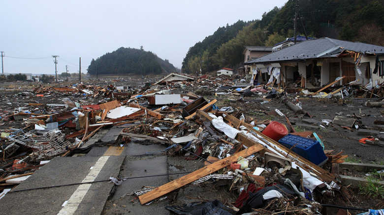
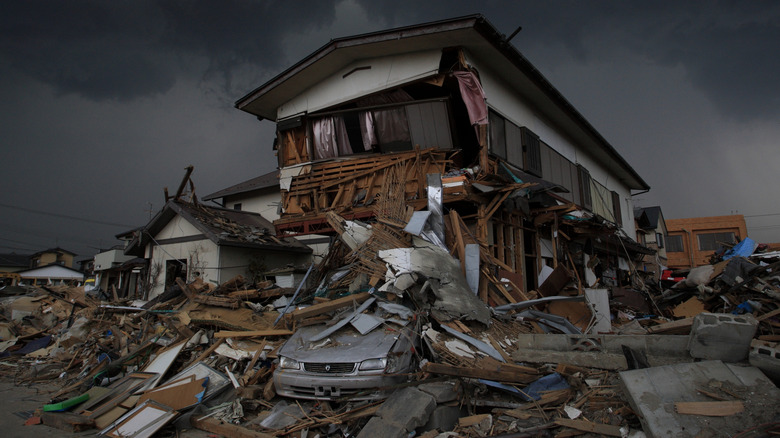
The Tōhoku earthquake, also known as the Great East Japan earthquake, is the most recent event on this list. It occurred on March 11, 2011, at 2:46 p.m. local time, when a portion of the subduction zone between the Eurasian Plate and Pacific Plate ruptured off the coast of Miyagi prefecture. Subsequent surveys indicated that a portion of the seafloor spanning thousands of square miles had moved over 160 feet east while shooting more than 30 feet upward, triggering not only a powerful magnitude 9.1 quake, but several aftershocks in the range of magnitude 6-7. In the aftermath of the earthquake, a series of tsunami waves flooded cities along Japan's northeast coast. Nearly 20,000 people were killed and more than 2,500 are still unaccounted for — over a decade later. The damage to local buildings and infrastructure displaced almost half a million people.
The Tōhoku earthquake also caused one of the worst nuclear disasters in history when a 50-foot-high tsunami wave shut down the power supply at the Fukushima Daiichi Nuclear Power Plant, causing three of its reactors to melt down. An extensive decontamination of the site was conducted, but some unconfirmed reports suggest that Japan may have released radioactive wastewater into the ocean – news that stirred international controversy. Due to the earthquake and tsunami occurring near a densely populated region and triggering a nuclear meltdown, the Tōhoku earthquake now ranks as the most expensive natural disaster in history, causing roughly $360 billion in damages.
3. The 2004 Indian Ocean earthquake (magnitude 9.1)
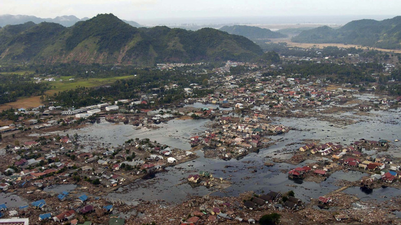
The third entry on this list is actually tied with the Tōhoku earthquake in magnitude, and the only other 21st-century quake in these rankings. It struck off the coast of the Indonesian island of Sumatra at 7:59 a.m. local time on December 26, 2004, and was caused by a fault line rupture approximately as long as the entire state of California. As with the previous entries on this list, the epicenter of the quake being offshore limited the damage from tremors, but the true threat lie in tsunamis.
The Indian Ocean earthquake triggered the deadliest tsunami in recorded history. Waves reached over 150 feet tall, causing floods that stretched for miles inland. Because the earthquake occurred in the Indian Ocean, the tsunami ended up rippling through the entire basin, with waves reaching the Horn of Africa, over 1,800 miles away. Even water level monitors in the Atlantic Ocean clocked the event.
The tremors of the 2004 Indian Ocean earthquake were felt in Indonesia, Bangladesh, Malaysia, the Maldives, Myanmar, India, Thailand, Sri Lanka, and Singapore; and the resulting tsunami affected 17 countries. While the Tōhoku earthquake may rank as the costliest natural disaster by monetary measures, this one took a far worse toll. The tsunami killed an estimated 228,000 people, making it by far the deadliest entry on this list, and one of the deadliest natural disasters in human history.
2. The 1964 Alaska earthquake (magnitude 9.2)
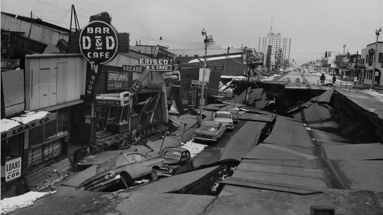
The Great Alaska earthquake of 1964 was the largest earthquake in U.S. history, and the largest ever recorded in North America. It is sometimes known as the Good Friday earthquake because it occurred on that year's Good Friday, March 27. The event was triggered by a portion of the Pacific Plate shifting to the northeast and thrusting the overlying North American Plate upwards. Portions of the land were driven up as high as 82 feet, while other portions sank up to 8 feet. The tremors lasted for four and a half minutes and were felt across an area of over 500,000 square miles.
The epicenter of the earthquake was in Prince William Sound, very close to the coastline and only 75 miles from Anchorage. Despite its proximity to a fault line, making Anchorage one of the most earthquake-prone cities in the world, many of the buildings at that time were not seismically stable. Massive landslides triggered by the quake destroyed roughly 30 blocks of homes and businesses, while pipelines for water, gas, and sewage were ruptured, cutting off vital resources. Tsunamis battered Alaska's southern coastline and dealt damage as far as Hawaii. So great was the disturbance to the global ocean that several fishing vessels in Louisiana were reported to have sunk that day. The earthquake and tsunamis killed 131 people, and it was only thanks to Alaska's extremely sparse population that the death toll was not far worse.
1. The 1960 Valdivia earthquake (magnitude 9.5)
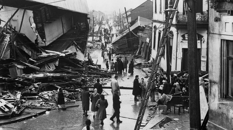
The most powerful earthquake ever recorded struck approximately 100 miles off the southern coast of Chile on the afternoon of May 22, 1960. It was caused by a roughly 600-mile-long portion of the Nazca Plate subducting beneath the South American Plate, causing tremors that lasted for 10 minutes. The earthquake was so strong that it pushed the Chilean coast westward, actually adding to the country's land area. This, combined with shoreline subsidence, permanently transformed the coast to the degree that navigational charts had to be redrawn.
The city of Valdivia, 11 miles inland, suffered the greatest damage, with almost half of its buildings destroyed. Within minutes of the tremors subsiding, tsunami waves up to 80 feet tall crashed down along the Chilean coast, dealing even more damage. An estimated 1,655 people were killed in southern Chile, but the destruction didn't end there. The tsunami surged all the way across the Pacific, killing 61 people in Hawaii, 32 in the Philippines, and 138 in Japan, which is more than 10,000 miles from the epicenter. The earthquake is also thought to have caused the Puyehue-Cordón Caulle volcano in the southern Andes to erupt two days later.