8 Free Google Maps Alternatives That Users Swear By
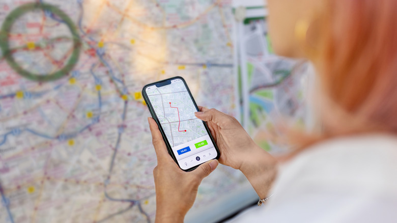
Google Maps leads the navigation app market, but if you've faced traffic jams while it promised to save time, or lost signal when you needed directions, you know it's not for everyone. Maybe you need real-time updates on community hazards and traffic events. Or perhaps you want offline maps that work without internet. You may prefer navigation for backcountry hiking, public transit, or RV travel. In these cases, a one-size-fits-all app won't work.
If this sounds like you, here's a selection of map navigation apps that actually fix those Google Maps headaches. They have been tried, tested, and considered what real existing users think about them. You could use ChatGPT for navigation, but these eight apps address unique needs without making you miss Google Maps. They are solid options that help you get where you're going according to your specific needs. Whether you need more real-time traffic updates or you're lost without signal, one of these apps has what you're looking for.
Waze is the crowdsourced traffic intelligence alternative
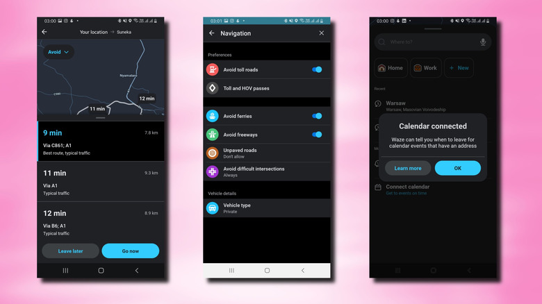
Waze runs on something simple: Regular people reporting what they see on the road. It could be an accident ahead, cops on the shoulder, construction closing a lane, potholes, or hazards. Users flag these in real-time, and Waze doesn't just note them — it reroutes you around them immediately. The crowdsourced data feeds directly into the routing engine, which means your drive time estimate actually reflects current conditions instead of historical averages.
Where Waze genuinely outclasses Google Maps comes down to specificity. Google shows traffic as a colored line. Waze shows you exactly where the problem is, how long it's been happening, and what other drivers near you are doing about it. You get alerts about specific hazards coming up instead of a general warning. Technically speaking, Waze validates incident reports using a reputation system where volunteer map editors maintain data quality and can spot false reports. To check how reliable Waze reports are, emergency dispatchers in Dallas-Fort Worth began cross-referencing crash locations with Waze reports, and they found that the map's user reports were more accurate than traditional 911 call mapping.
The app also handles the logistics of driving better than you might expect. Calendar integration means it predicts when you need to leave based on traffic forecasts. Toll prices compare in real-time, so you can pick cheaper routes. Gas prices update along your route. If you drive the same commute daily, the app learns your patterns and grows progressively smarter about anticipating problems before they hit. The app has 4.1 stars from 8.8 million reviews on Google Play Store and 4.8 stars from 3.1 million on Apple's App Store.
MAPS.ME provides lightweight offline maps for global travel
Here's where MAPS.ME solves something that keeps many travelers up at night. Your phone suddenly loses signal, leaving you navigating blind. MAPS.ME will let you download complete offline maps around the world, and the file sizes stay small enough that you're not burning up your entire storage on maps. This map has 4.7 stars from over 75,000 reviews on Apple and 4.6 stars from over 1.25 million on the Play Store.
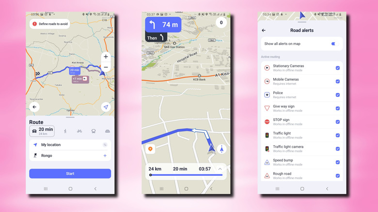
The maps are sourced from OpenStreetMap, which is community-maintained. Anyone with knowledge of an area can edit and contribute. That means the data stays fresher than you'd expect from something free. You also get many types of road alerts, but you have to select the ones you're interested in manually. Some of these alerts include stop signs, police, traffic light cameras, traffic lights, speed bumps, and rough roads. Like Waze, MAPS.ME also lets you define which types of roads you want to avoid.
Once you download a region, you get full turn-by-turn navigation without internet. Searching for restaurants, hotels, ATMs — all offline. Reviews and opening hours display right on the map. This matters when you're driving through rural areas, national parks, or countries where roaming charges would bankrupt you. The app throws in travel guides created by actual travel writers, saving hours of research. You can bookmark places you discover and plan to return to later. Hotel bookings integrate with Booking.com directly from the app.
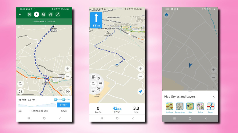
OsmAnd functions as a Swiss army knife for hiking and off-road navigation
OsmAnd isn't the most elegant navigation app in these selections, but it does a really good job for people who actually go places Google Maps doesn't. Hikers, off-road drivers, and backcountry explorers could benefit from this one. The ratings, 4.6 on both Play Store (227,000 reviews) and App Store (5,200 reviews), come from people who've tested the app on actual difficult terrain.
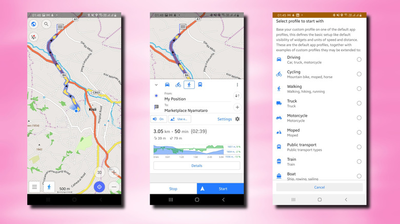
OsmAnd is designed for serious outdoor use thanks to its routing profiles. There are 12 profiles: driving, cycling, walking, truck, motorcycle, moped, train, boat, aircraft, skiing, and horseback riding. Each profile routes completely differently because it's optimized for what that vehicle actually needs. For example, the mountain bike profile (under cycling) focuses on dirt trails and avoids highways. You can also manually exclude whatever you want to avoid, like toll roads, ferries, unpaved surfaces, and even drag waypoints on the map to customize individual turns.
Advanced features include ski routing, dedicated mountain biking trail data, and highlighting exactly where elevation gains and losses occur on your route. Hiking rendering styles display trail difficulty, visibility, natural reserves, and points of interest highlighted specifically for people on foot. You can also record GPX tracks, create waypoints with custom icons and colors, organize them into groups, and export everything. The free version gives you plenty to work with, though some features live behind a paywall.
Organic Maps is the privacy-first open source navigation choice
Organic Maps is built on a different philosophy than every other app on this list. It's open-source. It doesn't throw ads up between you and its content, and it doesn't track your data. It has 4.8 stars on the App Store and 4.7 on the Play Store, though with a fraction of the number of reviews of some entries on this list. This is impressive and a good sign, given that it has far fewer users than its competitors.
Navigation includes hiking, cycling, driving, and walking, all with turn-by-turn voice guidance. The offline maps feature trails, cycling routes, walking paths, contour lines, elevation profiles, and peak data. Any searches you perform can be retrieved offline. You can import and export bookmarks in standard formats like KML, KMZ, and GPX. Dark mode helps protect your eyes at night. The app has actually been verified by privacy organizations. Exodus Privacy Project and TrackerControl for iOS both confirmed zero trackers.
What you won't get from Organic Maps is real-time traffic or incident reporting since those require constant internet connectivity. No premium tier or subscription exists. The entire app is free and stays free because it's community-funded through donations. Battery drain stays minimal because it's built for offline operation from the ground up. That matters on multi-day trips where charging opportunities are limited.
Citymapper brings multimodal public transit integration to life
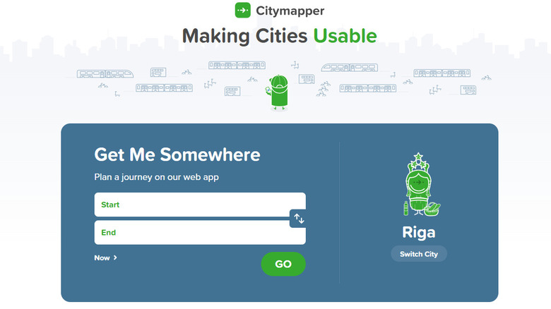
Citymapper combines buses, trains, trams, ferries, subways, taxis, ride-shares, bike-shares, e-scooters, and walking into one interface that actually talks to itself. Instead of planning one leg of a journey in one app and the next leg in another, Citymapper shows you everything. The platform connects over 50 million riders and utilizes proprietary algorithms that merge transit and driving networks to offer commuters on the go a comprehensive route from A to B, a feature that most competitors don't provide.
Real-time tracking shows you your bus or train getting closer as a dot moving across the map. Live wait times indicate the time until the next departure. Alerts notify you before you miss a connection. Navigation through each leg of the journey automatically tells you when to get off and suggests the best exit at stations. Citymapper allows you to quickly compare ride-share prices, check bike availability at a station, and view e-scooter charge levels. Additional features include integrated ticketing — you can buy single, day, and weekly passes directly in the app without switching apps, depending on availability and what city you're traveling in.
Citymapper covers hundreds of cities globally, though coverage varies by region. The tradeoff is that it doesn't handle long-distance driving or routes through rural areas. Urban mobility is where it excels, which makes it essential if you navigate cities regularly and invaluable when you're exploring a new city.
Roadtrippers specializes in planning road trips and RV adventures
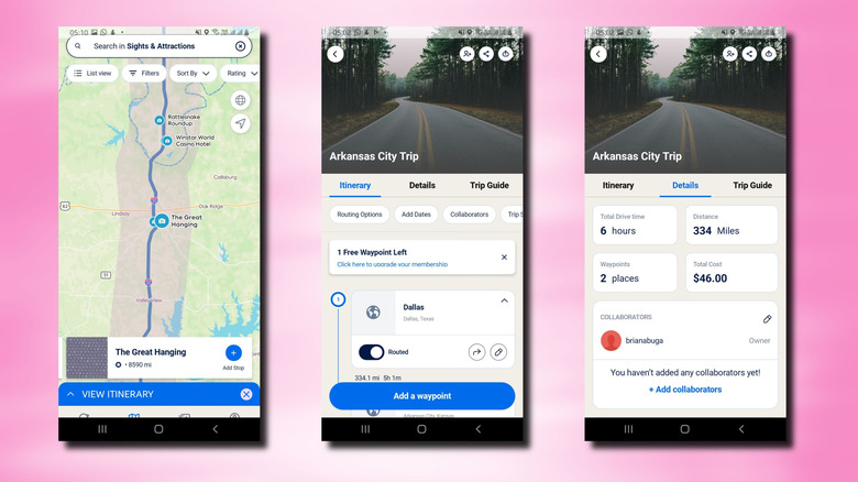
Most of Roadtrippers' great features require a paid membership, but it's worth mentioning, especially for RV owners. Google focuses on logistics, but Roadtrippers highlights fun stops, attractions, and campgrounds along your route. If you own or rent an RV, it has a special paid feature: dimension-based routing. This helps you avoid roads that are too narrow or low for your vehicle. You input your RV's dimensions (length, width, height, weight), and the app adjusts suggestions accordingly.
Set your preferences to avoid ferries, toll roads, or dirt roads. Roadtrippers will then create routes that fit your travel style. Each suggested stop includes campground reviews, photos, historical info, and practical details to help you choose. The database highlights hidden gems — secluded picnic areas and roadside attractions that are often overlooked by regular maps.
Route planning actually accounts for how RVs travel, not just assuming highways are always best. Real trip planning means picking campgrounds where you want to sleep, and Roadtrippers integrates all the information you need to decide. You can plan multi-week trips with a dozen stops, save them, and come back later. Roadtrippers lets you plan your trips manually, but it can plan your trip for you with a premium subscription. It has a 4.6 rating based on 61,000 reviews on the App Store.
Yandex Maps and Navigator provides regional coverage for Eastern Europe
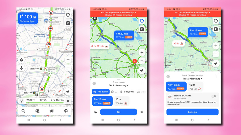
Western navigation apps have a geographic blind spot that Yandex Maps fixes. If you travel to or live in Eastern Europe, Russia, Turkey, or Central Asia, Yandex actually has detailed coverage that rivals or beats alternatives in those regions. The app holds a 4.6 rating from 1.6 million Play Store reviews and 4.7 from 27,000 on App Store, reflecting strong satisfaction among people who live in those areas.
Coverage includes over 2,000 Russian cities and 20+ countries. This list features Belarus, Kazakhstan, Turkey, Hungary, Ukraine, the Baltics, and more. Navigation supports driving, walking, public transit, cycling, and scooting. It offers real-time traffic updates in major cities. Voice search allows for hands-free operation. Points of interest let you book appointments or order food directly in-app in supported regions.
Offline map downloads enable navigation for when connectivity drops. Street panoramas and 3D mode provide context that helps you understand locations. The interface supports Russian, English, Turkish, Ukrainian, and Uzbek, making it genuinely accessible for regional users. If you travel frequently in Eastern Europe, no other option provides better local information.
AllTrails offers a community-curated hiking and trail database
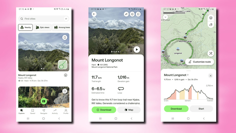
AllTrails has a database with over 400,000 trails. A team of outdoor lovers makes sure the information is accurate. Ratings on iPhone and Android are high (4.9 and 4.6, respectively). The app keeps its promises without shortcuts. AllTrails stands out by clearly marking verified routes and OpenStreetMap segments. Verified routes appear as solid green lines, while community data shows as dashed lines. This distinction helps users quickly identify which trails are verified and which depend on user input.
You can find trails using filters like distance, difficulty, elevation gain, activity type, and dog-friendliness. Hiker reviews offer honest insights to help you decide. The app provides turn-by-turn navigation, elevation profiles, and estimated times. It gives directions to the trailhead, tracks your activity, records your statistics, and allows you to upload completed hikes.
AllTrails also has a feature called Community Heatmap (subscription) showing the most-used routes, making it easier to find popular trails, discover lesser-known ones, or avoid crowds. Weather forecasts and ground condition predictions help you prepare. Live Share lets friends and family monitor your hike, combining safety with connection. The free version offers great value. However, premium subscriptions give you offline maps, advanced planning, and heatmap data. Whether that's worth breaking the paywall is up to the user's hiking frequency and goals.
Methodology
All the app selections have at least 4 stars and 1,000 reviews on both the App Store and Play Store. This ensured consistency for iOS and Android. Each was then evaluated for core features, navigation, offline capability, and overall ease of use. The selections drew from app store reviews on both platforms, BGR's previous coverage, and analysis from specialized outdoor and travel publications. Priority was given to apps that solve specific problems Google Maps ignores or handles poorly.