

Here's How To Get Different Colored Roads On Waze (And What They Actually Mean)
Waze functions a lot like Google Maps (it's also owned by Google) in that both use visual aids to inform users about what's going on around them. In particular, Waze has some quirky and colorful icons, usually placed by the rest of the community, but it also uses colors in general to help you discern the mood for an area. For example, dark yellow and orange roads tell you that there's light to medium traffic currently. As expected, the color red indicates heavy traffic and major slowdowns.
Typically, these color-coded roads will show up by default when you use the app, but you can also turn them on by opening the menu (three lines in the top left), going to Settings > Map Display, and making sure the 'Traffic Flow' or 'Show on Map Traffic' options are toggled on. This default view is one of two color options for the service. The other is a color scheme used to denote when map editing is active. The difference between them is that in editing mode, the roads and accessways are highlighted to indicate which type of road they are, versus traffic flow, so you can easily see where there are major and minor highways, on- and off-ramps, parking lots, private roads, and so on.
You can actually turn on editing mode the same way you'd turn on traffic indicators. Under Settings > Map Display > Type, select Map Editors. It's the only other option besides Default. For the most part, the road and line colors in Waze are going to tell you how bad traffic is along your route, and that's that.
The same colors may indicate specific levels of traffic
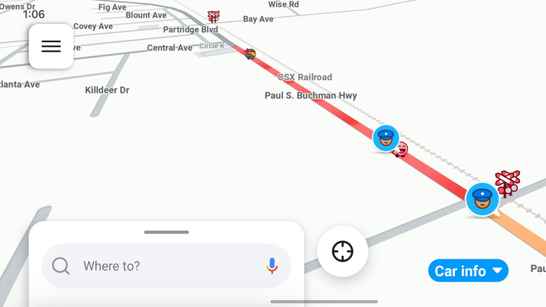
Depending on the traffic, Waze may utilize several different shades of the same color. You'll see this most commonly with the color red. The intensity of the red on screen reveals just how bad traffic is. Light red means moderate traffic, which doesn't necessarily indicate a major slowdown. It's simply telling you the traffic is congested and may or may not get worse.
Standard red, a little darker and a little less transparent, means that traffic has actually progressed to a slowdown or stop. Dark red means true bumper-to-bumper traffic, a major slowdown, definite travel time changes, and is something you'll probably want to avoid altogether if you can help it, while planning your trips.
Besides those colors, you'll also want to familiarize yourself with what all the icons and emojis on Waze mean, as they're all telling you specific things, as well. The traffic and road condition icons are especially important as they show when and where an accident has occurred, where a police trap might be, or when roads are closed and other Wazers (Waze users) need some help. In a Google Maps versus Waze head-to-head for navigation alone, Maps still wins out. But for Waze fans, all those user avatars, icons, colors, and theme-like additions really make a huge difference, and that's something.
Why is the Map Editor mode colored and styled differently?
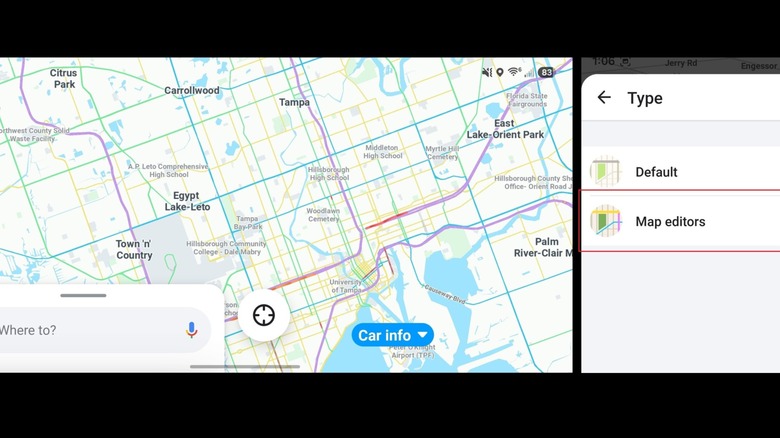
The actual Waze map editor is a desktop-based tool accessible within a browser. Anyone can modify maps as long as you sign in with the same account you use on Waze proper. This allows community members to make much-needed adjustments, like when an address is wrong or streets are missing from the map. The community support is one of the reasons Waze is simultaneously better and worse than Google Maps. The Map Editor color style allows you to use the app, even on mobile, to see street and road types and better understand what you're looking at from a logistical viewpoint.
Presumably, you wouldn't be using your Waze app in this mode all the time, only when you're considering making adjustments or need to identify where changes are necessary. That's also why it's not the default color mode. Not everyone is interested in editing or updating the Waze maps; some people just want to use the service as a navigation tool.
Map editing is different than placing or updating the icons you encounter during trips, pinpointing hazards — those are usually shared by users. Anyone can do this, and from within the Waze app, as well. With Waze open:
- Tap the yellow hazard icon on the bottom right.
- It will ask what you see as a sub-category, like traffic, accidents, police, or blocked lanes, so select what's most relevant.
- Tap the Report button.
You may be asked for more information, like exactly where on the map the icon belongs or choosing which road direction is blocked.
What do the actual road colors mean in Map Editor?
As mentioned, the unique colors used in Map Editing mode, or the editing theme, tell you precisely what type of road you're looking at. Purple is used for interstates, which is a color you'll see exclusively in map editing mode — you won't see it in the default mode of Waze. In fact, people who have accidentally enabled the editing mode have found themselves confused by the various colors onscreen. The other colors are blue for major highways, green for minor highways, yellow for primary streets and county highways, medium or dark grey for standard streets and local roads, light grey for parking lots, and dark grey for ramps.
Road colors and styles may differ from country to country, so these colors are best used as a reference in the United States. If you want to see this for yourself, you can easily turn the mode on from within the Waze app, check it out, and then turn it off and return to normal. It won't hurt anything, and you won't be locked into a particular theme or mode. Again, that can be done by going to Settings > Map Display > Type and then selecting Map Editors.