

5 Google Maps Settings Drivers Should Enable
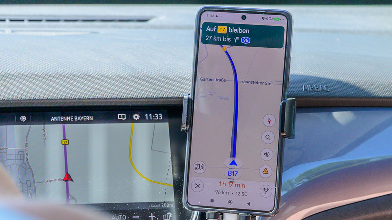
Google Maps is one of the most widely used navigation tools you can consider for your iPhone or Android device, even if you don't drive a car. Install the app, and you're ready to navigate to your next destination by walking or using public transit, or explore your surroundings. But drivers will make the most of Google Maps, as the app's primary function is to provide driving directions. You don't have to log into your account to set up navigation from point A to point B, and you don't have to dig into the app's settings to customize the experience. Google Maps has many features turned on automatically for the navigation experience, including turn-by-turn voice directions, live traffic support, lane guidance (where available), estimated time of arrival (ETA) information, and alternate routes. These are enough to provide the information you need while driving to your next destination. But Google Maps also offers several other settings that drivers should enable from the app's menus to improve their navigation experience beyond the default options.
Drivers should customize their car profile so Google Maps navigation can account for their vehicle type. They should consider downloading offline maps when driving through areas that have spotty cellular connectivity or in regions where roaming charges can add up. Other handy but optional features in Google Maps include sharing ETAs with friends and family and enabling playback media controls.
The newest feature to enable in Google Maps, especially on Android devices, is Google's Gemini AI chatbot. Gemini effectively replaces Google Assistant on Android devices, allowing you to control much of your navigation experience by voice.
Customize your car profile
By default, Google Maps assumes you're driving a gas car. The app can suggest the most efficient route to reduce fuel consumption, but drivers may own different cars, including diesel, electric, and hybrid vehicles. The last two options may require recharging the battery, especially in fully electric vehicles. That's why it's important to customize your car profile before you start using Google Maps.
To choose your car profile, tap on your profile image, tap Settings, and go to the Navigation menu on both Android and iPhone. Tap the Your Vehicles menu and choose your Engine Type from Gas, Diesel, Hybrid, and Electric. When you pick Hybrid or Electric, a secondary Plugs & Adapters menu will appear. Tap it, and you'll see various options, including Tesla plugs and others. A Vehicle menu may also appear that lets you add the make, model, year, and trim of your car.
EVs with Google Maps built into the car will offer users other handy features, like showing the estimated battery charge on arrival and adding stops for battery charging along the way. For Android Auto, supported EV models will also show battery predictions and charging recommendations. An "Add Charging" button can appear on the display when setting up your next drive. The regular Google Maps app can be used to search for charging stations – a feature that can help you plan stops along your route – but it doesn't automatically account for your battery charge or charging stops. Google Maps may display the estimated battery usage for trips on supported EV models.
Download maps for offline use
Google Maps requires GPS support and access to your location to provide turn-by-turn directions during your drive. Also, a cellular plan can provide the required internet connection for real-time information. Most phones support GPS, and Google Maps can access your location once you set up the app's permissions. Almost always, drivers don't need to worry about anything else when setting up navigation on their devices. However, those users who travel to remote places with spotty cellular connectivity and drivers who worry about overages related to mobile data usage or roaming charges abroad should download maps for offline navigation. Offline maps in Google Maps can also come in handy when navigating around natural disasters that may affect cellular service.
To download maps for offline use on Android, go to Google Maps, tap your profile image, and tap the Offline Maps option. Tap Select Your Own Map and then zoom in and out to adjust the area you want to download. You'll want to download a larger area to cover your entire route, but you should know that the larger the area, the more storage it will consume. The process is identical on iPhone. Regardless of your platform, you'll have to wait for your device to download the data. When offline, Google Maps will have more limited functionality, but it will support driving directions.
Drivers who happen to travel the same routes with patchy cellular connectivity should enable the "Auto-update Offline Maps" and "Auto-download Recommended Maps" features so their offline maps stay updated and relevant for their needs. These features are found in the Offline Maps menu on Android and in a Settings sub-menu of the Offline Maps menu on iPhone.
Share trip progress with family and friends
In addition to ensuring you have access to offline maps when internet access isn't guaranteed or affordable, you may want to take advantage of another feature in Google Maps that can improve your safety. You can share your estimated time of arrival with friends and family, especially when driving in remote areas and on unfamiliar routes. That way, another person can keep track of your location. On Android and iPhone, set up your navigation, tap Start, and then swipe up on the information card where a Share Trip Progress option will be available. Select the contact you want to share your trip with and tap Share.
Google Maps will keep sharing your live location until you reach your destination or end navigation. Additionally, you can stop sharing your location manually at any time when driving. In other words, this feature will require manual activation for each distinct trip. Google Maps won't automatically remember to share your trip, even if you repeat the same route.
Google Maps has another location-enabled feature that may be enabled by default or available to turn on. On iPhone, it's called Automatically Save Parking, and it can be handy when stopping at busy places. Google Maps saves the parking location automatically, retaining the data for up to 48 hours. On Android, you can save your parking location by tapping on the blue dot that shows your current location after you've parked the vehicle. The same procedure works on the iPhone, if you want to save your parking location manually.
Enable playback media controls
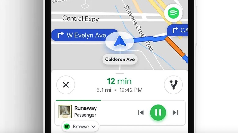
Some drivers will want to play music or listen to podcasts or audiobooks during drives, so they should consider adding playback media controls to Google Maps in supported markets. This will allow them to control playback from the app without switching back and forth between a streaming app like Apple Music or Spotify and Google Maps. On Android, go to your profile in Google Maps, tap Settings, and then Navigation. Tap Show Media Playback Controls and select the media app you want to use in Google Maps. Tap Next and then OK to enable the feature. For example, select Spotify from a list of apps, and the media controls for that player will be available at the bottom of the screen.
The procedure is similar on iPhone, but you'll be looking for Music Playback Controls in the Navigation menu. You'll also need to connect an app whose media playback controls will appear in Google Maps. You can change the app on both platforms from the same menus.
If you use CarPlay or Android Auto, you'll have separate access to media controls depending on how you set up the car's display. You won't need to set up playback media controls for Google Maps if you use navigation primarily through the car's infotainment system. But it may be a good idea to have the feature enabled in Google Maps if you routinely switch between cars, including models that don't support CarPlay or Android Auto. Finally, you can control music playback via voice on Android using Gemini or Google Assistant, after setting up the feature.
Enable Gemini AI
Gemini can be used to ask questions about your current route, including places of interest along the way. You can tell the AI to add stops by voice, which can be useful when deciding to take a break, stop for gas, or recharge your EV. Gemini may be faster at finding a restaurant that you like along the route than manually sifting through options.
To enable Gemini in Google Maps, you'll need to be signed into your Google account. Android phones may come with Gemini set up as the primary assistant instead of Google Assistant, in which case you don't have to do anything before using Gemini in Google Maps. Users will need to switch to Gemini on phones that still have Google Assistant enabled. Use the Google app to access the Settings menu of Google Assistant and select Gemini as the phone's assistant. Once Gemini is set up, you'll be able to use Gemini in Google Maps. Say "Hey Google" or tap the Gemini symbol after you've started navigating. Gemini will be able to control other connected apps on the handset.
On iPhone, start navigation mode and then tap the Gemini symbol that appears to chat with the AI. For a hands-free experience, you can enable a feature called "Go hands-free with 'Hey Google'" from the Navigation settings menu in Google Maps. Gemini is more limited on the iPhone and supports specific navigation and search features in Google Maps. Gemini can also access data from other connected Google apps installed on the iPhone.